 |
| Makah Bay, Olympic Peninsula, Washington |
For as long as I have known about Washington's Olympic Peninsula, I have had visions of this part of the world as being always grey and wet, shrouded in eternal clouds and hammered by incessant rain. And I am sure, at least part of this stereotype is correct since otherwise there would not be rainforests on the slopes of Mount Olympus. Some parts of the National Park receive in excess of 100 inches of precipitation a year, but did you know that in Sequim, lavender-capital of the USA, annual rainfall is less than in Lubbock, measuring 16 inches while the sun shines more than 300 days a year?
 |
| Approaching Deception Pass, going west |
 |
| Before the bridge was built, a ferry—skippered by a hardy woman—provided passage onto the island |
 |
| Using the engine to go into 9 knots of tidal current at Deception Pass |
For five days I traveled in counter-clockwise direction around the peninsula, experiencing the most beautiful Indian Summer weather that the Pacific Northwest can possibly dish up. This trip came more or less on a whim, precipitated by the loss of a bike race gig in Waco and the fact that $11.20 (and 90,000 miles) buy a First Class ticket from Lubbock to Seattle. It also helped that these five days fell right in the middle of a three-week vacation that Sabine and her son, Jonathan, are taking in that area, and we decided to explore the peninsula together.
 |
| Serene, tranquil, perfect for lunch |
 |
| Still life with kayaks |
 |
| Still life with cleat |
 |
| Still life with WTF? |
 |
| Post-lunch relaxation at Ebey's Landing |
I arrived on Tuesday, after just two nights at home after my trip to Louisville. When I landed, the weather was indeed dreary and misty, but only for that afternoon. Sabine had rented a car, and the three of us headed first north and then west to Fidalgo Island. We spent the night in Oak Harbor, just a few miles south of Deception Pass where a beautiful bridge makes the connection to Whidbey Island. Wednesday morning the sky was blue and the rain was forgotten, and it stayed like that for the remainder of my time in Washington.
 |
| The ferry to Port Townsend |
 |
| Mother and son—on a bad hairday! |
 |
| Hippies know art when they create it |
 |
| Some things are free ... |
 |
| ... and others are not—"Mom, can I have a dollar?" |
Before we took the ferry from Coupeville to the rather hippiesque Port Townsend on the peninsula, we walked around the historic Ebey's Landing area where things were
very quiet and
very laid back. The vistas of the Cascades in the distance were stunning, and we thoroughly enjoyed our lunch on the pier.
 |
| Looking upon Vancouver Island, just across the Strait of a certain Juan who was a Fuca |
 |
| Isn't that a beautiful name? The Dungeness Spit |
 |
| The Olympic mountains show off in clear, dry splendor |
 |
| G'night, Sun |
The short ferry ride brought more stunning vistas. Actually, most of the trip did! Be it the sea or the mountains, the beaches or the bridges, the forests or the sea stacks, it was all just so unbelievably
beautiful! I had hoped for an enjoyable five days of R&R, but I had not expected five days of pretty much non-stop scenery and exhalations of
wow..
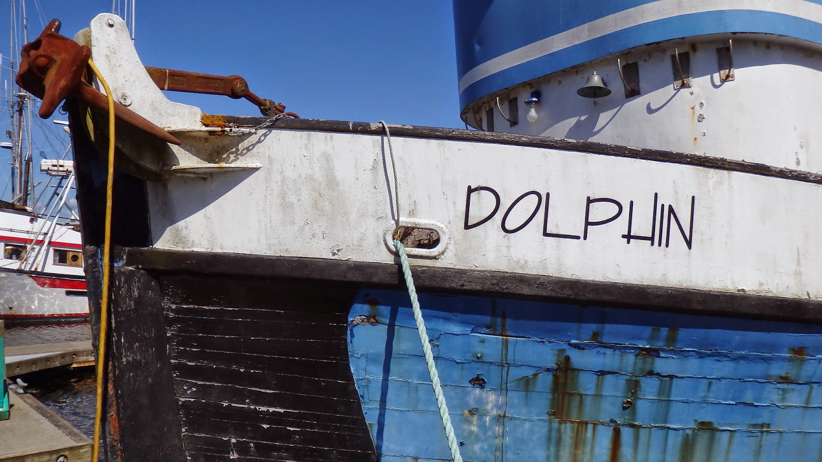
 |
| All pictures taken in the Neah Bay harbor |
A large part of the Olympic Peninsula is taken up by the eponymously named national park. The center piece is, of course, Mount Olympus. At just shy of 8,000 feet it is tall enough (and far enough north) to have glaciers. It is not a volcano as Mounts Rainier and Baker (and others) are, so there is not that perfect cone shape. The Olympus range, however, has a profound effect on the climate not only on its slopes but also to the east (and, indeed, the entire peninsula). Included in the national park are beaches and areas of temperate rain forest. We decided against driving high up on the ridge road (after all, Sabine lives close to the alps and I had just come back from Colorado) and instead concentrate on the areas that we don't usually get to see.
 |
| Looking upon Tatoosh Island, even a little farther out than where one can walk in the Lower 48 |
 |
| If this is not spectacular, I don't know what qualifies |
 |
| Cape Flattery, the north-western-most point in the Lower 48 |
 |
| Sabine's heart started thumping when she saw this beauty in the Strait |
The peninsula has a large indigenous population, with tribal lands often adjacent to the national park. Neah Bay is a typical fishing port, and we spent an hour walking around the docks and photographing the vessels, each one a study in picturesque functionality. From here it was just a short drive to the north-western-most point in the Lower 48, Cape Flattery. While Vancouver Island, BC, lies to the north across the Juan de Fuca Strait, looking due west shows nothing but the tremendous expanse of the Pacific, with Japan many thousand miles over yonder. Views, views, views!
 |
| Impressions ... |
 |
| ... from ... |
 |
| ... Makah ... |
 |
| ... Bay |
Before checking into our hotel in Forks (yes, the setting of the Twilight cult novels and movie) we spent the waning evening hours on the beach at Makah, another tribal community with a harbor sheltered by a breakwater that is littered with giant logs that look like bleached bones. The calm, sunny weather belied the force with which gales will pound these shores. We stayed until the sun finally dipped into the Pacific, the second ocean sunset for us after the previous evening's spectacle at Dungeness Spit close to Port Angeles.
 |
| Consumables |
 |
| Collectibles |
We enjoyed these sunsets, so much that the following evening we went for a repeat at Ruby Beach. Here, numerous sea stacks increase the drama of the scenery even more. Serious photographers with tripods and big lenses were out in full force but were dwarfed by the immense expanse of beach and sea. I had to make do with my little Olympus point-and-shoot, but sometimes the angle of attack is more important than the measure of megapixels.
 |
| A spruce towering well over 200 feet |
 |
| Please click on this panoramic view of Middle Earth |
 |
| It really should have been raining, or at least misting |
 |
| Maybe my favorite shot of the entire trip |
Twilight. Honestly, not being the father to some teenager I wasn't even aware of the whole thing outside of having read something in Time magazine about it sometime back. But there is a reason why Forks makes such a good setting for whatever it is that Twilight is trying to be: It is just a few miles away from one of the few temperate zone rainforests in the world. As hinted above, it seems incongruous to be walking around in a "temperate rainforest" when it is 80 F and the sun is hitting hard. Thank goodness, I have been around enough to know how these mossy and ferny places look like with dripping moisture. If you want the full ambiance, wait until the next batch of those 100 inches rolls around, but if you want to take pictures and enjoy your walk through the Hall of Mosses (no, Hermina, it is
not Moses!), pick a picture-perfect afternoon during the Indian summer. The blackberries are gratis.
 |
| The Hoh river, coming down from Mt. Olympus |
 |
| A rivulet, next to the Hoh—collecting moisture and gently carrying it onward |
The Hoh (another Indian tribe) rainforest on the Hoh river, which is born 7,500 higher up at the glacier, allows you to travel to Middle Earth, or some Twilightian place. We didn't see gnomes, even though they must live here, but thankfully we saw very few tourists in return. I kept flashing back to that day when my good buddy Kai took me up to "his" redwood forest where he keeps some geo-caches, and how the fog had been rolling in over the ridge, making everything drip from the Humboldt dampness. So, it was easy for me to imagine what the Hoh rainforest is like most days of the year.


Another sunset on the beach. Cairns that beach combers have lovingly placed on driftwood logs. Seagulls that scream overhead, while the incoming tide reclaims just a little more real estate with every roller that washes ashore. Fish eggs that look like sea tears, washed up with the waves, each picking up a bit of black beach sand, the embryos well protected unless you step on one of them. The sun imperceptibly sinks, a bit more, a little bit more—yet, it seems to take so long as we are a long way from the equator. The green flash never materializes. We leave, oh so satisfied.
 |
| All of the above taken at Ruby Beach |
On our last day we went for another long walk on a beach. What is it that is so alluring to take off one's shoes and head for that elusive point at least a mile away, or is it more? Down on the beach it is cool, despite the sunshine—the Humboldt Stream has carried cold water all the way from Antarctica up to here. So many things suddenly seem to fall into perspective, yet thinking about how mankind is affecting weather patterns and thus also these seemingly axiomatic patterns is somewhere worrisome.
 |
| One of several bridges in Aberdeen |
 |
| The tides leave their mark |
And so we got back into the car, drove down to Hoaquim and Aberdeen, had a final picnic by one of the many bridges across the rivers and estuaries, and then headed back to Seattle, via the state capital of Olympia.
 |
| Tourists! |
 |
| Mt. Rainier, peeking through |
I didn't expect a trip of this magnitude. I had traveled in the Pacific Northwest, but this trip—maybe because of the weather? the circumstances? the company? all of the above?—was a 5 star on the 5-star scale.
Jürgen


No comments:
Post a Comment