 |
| Una palma en la Palma |
Our 10 days here between Tijarafe and Puntagorda on the tiny island of La Palma are slowly coming to a close. With an hour of downtime after our visit to the old "harbor" of Puntagorda and our evening reservation at the restaurant Murilla Sabine and I are sitting on the porch of our rental home, overlooking the Atlantic 800 meters below us and 2.7 kilometers away as the crow flies. Yep, this place is steep! The island may be small, but getting around takes patience since the roads are more curvy and steeper than anything I have seen anywhere. As we continue to repeat time after time on this trip: Thank goodness we didn't bring bikes.
 |
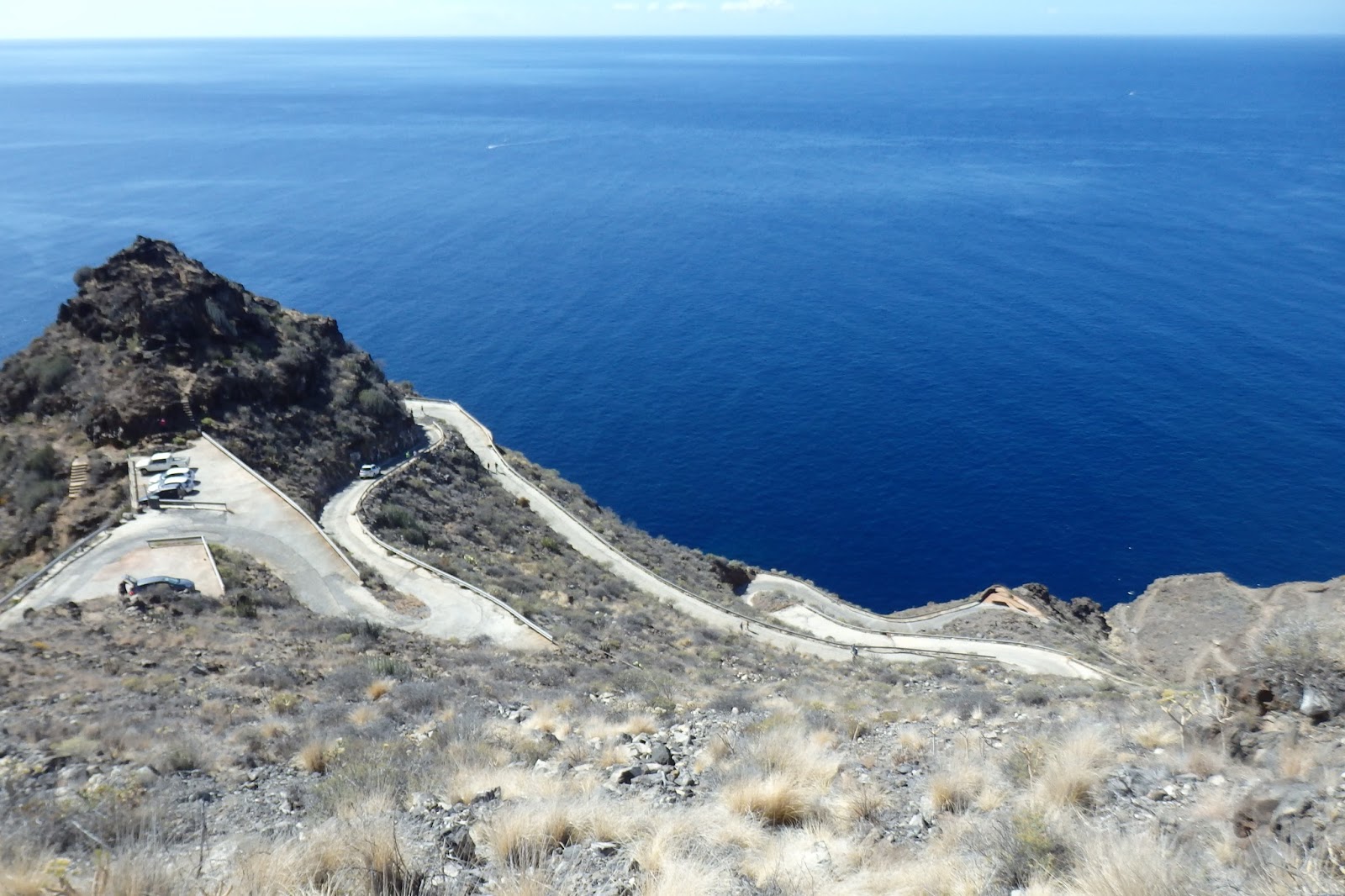
| First you drive serpentine after serpentine of steep roads ... |
 |
| ... and then you park the car and it gets really steep! |
La Palma is located in the southwestern area of the Canaries, which themselves are located in the Atlantic west of Africa (Morocco). Similar to Madeira, they typically enjoy a year-round climate of spring-like conditions with a long dry season and a much shorter wet season that allows large forests to grow on the windward slopes of the volcanic islands. Our various guidebooks gush about the verdant valleys with rushing water, but it seems that climate change is starting to take its toll here, too. The always predictable rains have not arrived the way they did for centuries, and much of what we have seen of La Palma is desperately parched. Our house, located on the west side of the island and surrounded by a pine forest, reminds me of all those homes in California that recently were destroyed when fires raged through sonoma and Napa. As a matter of fact, on our hikes we have seen many indications of large forest fires over the years,with only the most hardy pines surviving. Just in case I parked the car every night Kojak-style for a better chances of escape. Really.
 |
| The countryside is parched |
 |
| Dry and diseased paddle cactus |
 |
| Typical palmero house in the north-west part of the island |
 |
| Almond about ready to fall off the tree |
 |
| The pine trees are green, but fires have removed any underbrush |
We had decided on La Palma because we had been looking for a warm destination, preferably a place we hadn't visited before, that we could reach by cashing in some American Airlines miles. We hit the jackpot with a one-stop flight from Munich on Iberia. A few miles and a moderate co-pay were all it took to cover transportation. Bonus: On the way out we had an 18-hour layover in Madrid where we saw my old buddy Howard and his family, who live less than 10 minutes from the Barajas airport. Using a German rental car website I was able to secure a Citroen for our 10-day stay for less than $6 a day--however, I have to admit that we spent another $95 on full insurance since we were not able to decline some of the coverage that was automatically included in the rental and my credit card company was a bit iffy in regard to whether they'd cover any eventualities if I didn't nix any supplementary insurance. So, that left the VRBO rental of our wonderful house, which came to about $100 a day for first-class accommodations.
 |
| With Howard and his wife, Lidya, and the always-lovely Karen on the way to La Palma |
 |
| The little Citroen somehow managed all those steep inclines. Kudos! |
 |
| Our VRBO rental, built into the mountainside with a porch that overlooked the Atlantic |
La Palma has so many faces. Every day we have gone on hiking excursions, and every day has been different. It's hard to pinpoint a favorite. Whether you hike through laurel forests and get bombed by falling chestnuts (and the edible kind has some very pointy husks!), or you cross lava fields that are just 50 years old, whether you hike above the clouds and the astronomic observatories on 2,426-meter-high Roque de los Muchachos, or cling to almost vertical cliffsides on the way down to the old port of Puntagorda, it all is stunningly beautiful. No wonder so many Germans come down here to hike and enjoy the sun. If Madeira is firmly in British hands, well, the Germans have laid claim to La Palma.
 |
| A gaggle of German tourists on a guided hike |
 |
| Edible chestnuts hurt your head when they hit you! |
 |
| Normally, this photo should be dripping with water! |
 |
| Dragon trees |
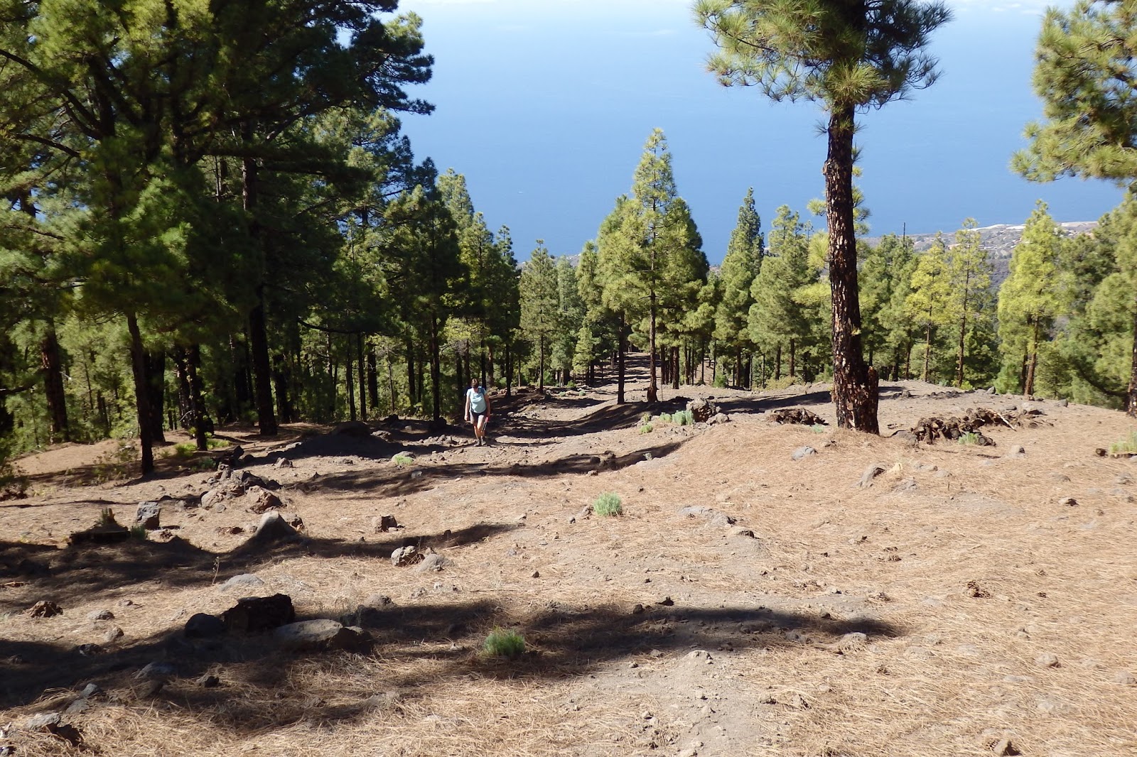
Without going into blow-by-blow details of our hikes, here are some generalities. First of all, we lucked out with the weather in that every day was calm and sunny (not a good thing for the local plant life, but we took the bonus). When I bring up "calm," please remember that this island is surrounded by the sheer endless Atlantic, and if it blows in Lubbock all the time, well, it should gale here! But not while we were here. We had read about the quickly changing weather conditions and how important it is to always carry raingear and a warm hat, especially when hiking at elevation, but we had no problems. In the sun it was warm, if not hot; in the shade, temps were in the high 60s, as they were at night. In other words, we experienced the most beautiful of late falls one can imagine, except that this seems to be the norm here.
 |
| Trails were well marked, but this cairn went a little overboard! |
 |
| All you need is a map and a general idea of where you want to walk |
 |
| A vineyard at about 1,300 meters |
Of course, we had brought our hiking boots, and without them not much would go here. The trails are rocky and often loose, and the steepness is staggering. If you don't have proper footwear, you're not going to get far. Navigating was much easier than expected. I had downloaded a free app called Locus Maps that allows to use detailed maps off-line, and the accuracy of the map for La Palma was simply amazing, down to the last few meters. Established and marked hiking trails, roads (paved or unpaved), minor trails and local footpaths are all captured, and with instant GPS location we were able to follow routes that we had mapped out the night before (with an internet connection). Add to that descriptions from the guidebooks that Sabine had on loan from some friends and the local library, and the generally excellent rail signage, and we were set. Add two small backpacks, collapsible hiking sticks for the worst of trails, and a few waterbottles plus a daily lunch, and you're ready to roll.
 |
| The north coast is much wetter than the western part of the island |
 |
| All beaches on La Palma feature black sand |
 |
| Trying to suck in our guts ... |
 |
| When was the last time you were above the observatories? |
Daily distances varied between about six to eight miles, which at first doesn't seem to be all that much until you realize that about 2,100 to almost 3,000 feet of elevation change were packed into these relatively short distances. When we hiked, we hiked--and at the end of the day, our legs told us that they had done most of the work. Fortunately, it was never very far from wherever we had parked the car to the next little town and a
kiosk where we'd have a beer and a few
tapas before heading home. We even found the allegedly one-and-only operating microbrewery on the island, Cerveceria Isla Verde, at the end of one long hike just a few miles from home. Yeah!
 |
| Beer on the beach (after packing it in) |
 |
| Big cold beers ... |
 |
| ... and yummy tapas |
 |
| The bird kept us entertained |
As mentioned earlier, we were on the west side of the island, which sees more sunshine and less rain than the north and east. Most of the big banana plantation are located here, and with their immense tent structures that protect the plants they look like giant concrete bunkers. A very strange sight. There are also unprotected plantations. and we could never figure out the difference. Back in the late 19th century bananas became the major export commodity for the island, making their way mainly to Britain. Even today they are the biggest money maker, even ahead of tourism. Of course, much of that success seems to depend on funding by the EU. Sabine has an insight or two into how EU moneys are being doled out for projects both deserving and totally asinine--one of them, a 50+ million euro harbor in Tazacorte whose only purpose is to attract aliens as a gigantic spaceport, or so it seems. Shipps of the kind it was built for have never anchored here.
 |
| Banana plantation with tent cover |
 |
| All those beige-colored areas are banana plantations under tents |
 |
| Some of the tents are starting to fall apart |
 |
| Inside of a tent |
 |
| The ultra-modern (and unused) Tazacorte harbor |
 |
| Old-fashioned fishermen with the day's catch of bonitas |
 |
| There's a reason they call them yellow-fin tuna |
We saw a few other buildings and projects that looked totally out of place, obviously subsidized with money from richer European nations who have no idea where their tax dollars flow in the grand scheme of things. Maybe the Brexit has some valid footing.... It wasn't quite clear to us whether the roads and streets that cling to the mountain sides like strings of swallow nests are simply the pinnacle of the evolution of ancient walking paths or whether EU money has played a role here as well, but they sure are miracles of civil engineering and old-fashioned construction. Rock walls holding back the mountain sides are examples of the finest imaginable stone-masonry. And if you think a road can't get any steeper, well, it can.
 |
| Cave building at Cueva de la Candelaria |
 |
| The steeper, the more secluded |
 |
| Late afternoon sun on the west coast of La Palma |
 |
| Crossing the lava fields |
Every one of our hikes had a different character, and every day we saw new stuff. For example, I had never heard of the dragon trees that one finds mainly in the northwest corner of the island.
Gofio was another new one to us, a type of flour ground from various cereals that then are fortified with whatever may be available, such as lupine seeds. The original inhabitants of the island (conquered by the Spanish in 1492 just before before Columbus launched his final hop across the Atlantic to discover the Americas) already knew of
gofio, and it still is a staple for the older Palmeros. We visited a
gofio mill, which reminded me of our world-class windmill museum in Lubbock.
 |
| The old gofio mill close to Puntagorda |
 |
| No, we were not flying when I took this photo of the immense port facilities of Tazacorte |
 |
| Dragon tree stands close to our house |
Hiking along the Caldera de Taburiente was one of the most impressive sights we had, if one discounts the immensely steep and abrupt cliffs that fall into the ocean. The views that we had of this ancient caldera, down toward Tazarote and the banana plantations will stay with me for a long time.
 |
| Hiking along the rim of the Caldera de Taburiente |
 |
| The Caldera de Taburiente in the afternoon light |
 |
| That's what it must look like on Mars |
I could go on and on, but it's time to close things down and publish this blog post. La Palma is a bit out of the way, but from what we saw, I'd recommend a visit to anyone who's looking for something extraordinary.
Jürgen


Eine wunderschöne Insel....steht sich mal mit auf unserem Programm.
ReplyDeleteLG Ute
Thank you so much for such an wonderful blog. I’m really thankful to you for this informative Blog .
ReplyDelete